In preparation for an upcoming five-week stint as artist-in-residence at Struts Gallery May 22 – June 25, 2011, I have been doing some remote location research. The noun location refers both to a physical place (site), and to the act of locating that place. The verb location refers to the identification or discovery a place or location. The location exists before it is located. The act of location sets, fixes and establishes the location’s position, which is to say, provides a context for place. Location may be assigned by measurement, by survey, by knowledge, or by opinion. I locate the following act of locating Struts Gallery within the discourse of residency. Because knowing where you’re going is not a prerequisite for travel. But knowing where you are arriving is helpful for staying.
Struts Gallery is located at 7 Lorne Street, Sackville, New Brunswick, the Maritimes, Atlantic Canada, Canada, North America, the Northern Hemisphere, the Western Hemisphere, the Western World, the G8, the G20, the Earth, the Solar System, the Milky Way, the Universe, etc.
The town of Sackville is located in Westmorland County, on the southern part of the Isthmus of Chignecto, which joins the peninsula of Nova Scotia to mainland New Brunswick. Sackville was first known as Pre des Bourgs and the surrounding region as Beaubassin by the Acadians who settled there in 1672. Pre des Bourgs, Beaubassin, Acadie, Nouvelle France, the New World, the Earth (which is round), the Solar System (which revolves around the Sun), etc.
According to Wikipedia the Beaubassin seigneury, granted in 1684, was named after Michael Leneuf de Beaubassin the elder (1640–1705), an officer in the French Navy who seized three English vessels from Boston that were taking on coal at Cape Breton. Beaubassin is a place named after a person named after a place, a location located withing the discourse of residency. Cape Breton is a place named in passing. According to the Dictionary of Canadian Biography Online, in a letter dated 8 July 1524, Giovanni da Verrazzano “records the earliest geographical and topographical description of a continuous North Atlantic coast of America derived from a known exploration.” In the world map drawn by his brother Gerolamo da Verrazzano in 1529, the “land which the Britanni (Britons) found” is named Cape Breton.
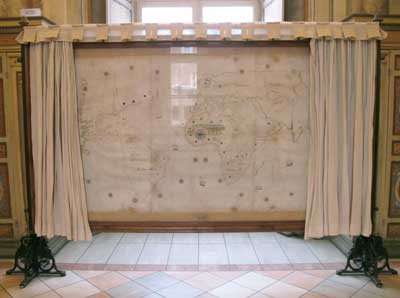
Gerolamo da Verrazzano, 1529, Vatican Museum. Photo: J. R. Carpenter, 2011
The naming of Cape Breton is relevant to the locating of Sackville because Sackville (Pres des Bourges) was once, and some would argue still is, in the heart of Acadie. According to Andrea di Robilant, the name Acadia may also be attributed to the Verrazzano brothers:
“Some linguists say the place name [Acadia] was derived from caddie/quoddie, a word used by native tribes to designate a fertile region. But others say it is not derived from a native term at all and that it was introduced into the language by Giovanni da Verrazzano in 1524: while sailing north of Chesapeake Bay, he called the coastal region Arcadia because it brought to his mind the pristine beauty of mythical Arcadia… Then the r was dropped when Verrazzano’s diaries were transcribed, and Arcadia because Acadia or Acadie, as the French possessions along the coast of Canada were known.”
Andrea di Robilant (2011) Venetian Navigators: The Voyages of the Zen Brothers to the Far North, London: Faber & Faber
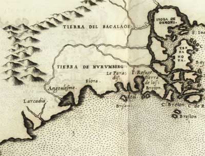
Girolamo Ruscelli, “Geografia di Claudio Tolomeo Alessandrino Tradotta di Greco nell’Idioma Volgare Italiano da Girolamo Ruscelli,” published in Venice in 1561.
Italian brothers sailing for France give an ancient Greek name for a mythological place to a coast seen from a ship. In this act they (re)locate a previously existing (and thus, presumably, previously named) location within the discourse of Nouvelle France. Variations of Verrazzano’s map were widely reproduced throughout the sixteenth century, with new place names added as they were discovered and altered as territorial ambitions grew. By the sixth edition of Ruscelli’s Geografia, published in 1598, Nova Francia has been clearly etched in above larcadia, though the first permanent French settlement in North America was not founded by Champlain and Des Monts until six years later.
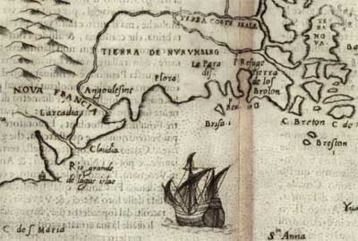
Girolamo Ruscelli, “Geografia di Claudio Tolomeo Alessandrino Tradotta di Greco nell’Idioma Volgare Italiano da Girolamo Ruscelli,” published in Venice in 1598.
The French settlement at Port Royal was much further north than the stretch of coast the Verrazzano brothers had likened to Arcadia. Yet throughout the Voyages of Samuel de Champlain, published 1612, the name La Cadie is loosely used to refer to any French territory, most of which were also “fertile regions” – in the summer, at least.
“De Monts had obtained from Henry IV., though contrary to the advice of his most influential minister, a charter constituting him the king’s lieutenant in La Cadie, with all necessary and desirable powers for a colonial settlement. The grant included the whole territory lying between the 4Oth and 46th degrees of north latitude. Its southern boundary was on a parallel of Philadelphia, while its northern was on a line extended due west from the most easterly point of the Island of Cape Breton, cutting New Brunswick on a parallel near Fredericton, and Canada near the junction of the river Richelieu and the St. Lawrence.”
Samuel de Champlain, Voyages of Samuel de Champlain, Vol. 1: 1567-1635, translated from French by Charles Pomeroy Otis, Ph.D., Boston, November 10, 1880
Could Sackville be said to have roots in Arcadia? It is hard to say. The concept of Arcadia has always been a shifting one. The people who come to settle in La Cadie – a place named after another place named after a mythological place – become a people of La Cadie by dint of their residency in it. I will not become an Acadian by dint of a five-week stint as artist-in-residence at Struts Gallery. When the British expelled the Acadians from Acadie in 1755, their name became their nation and travelled with them. The meaning of all the named locations left behind changed.
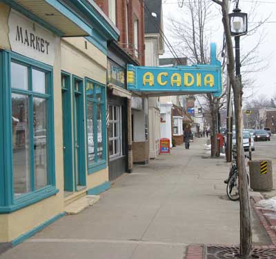
The Acadia movie theatre in Wolfville, Nova Scotia, home of Acadia University,formerly, my home town. J. R. Carpenter, 2008.
The region formerly known as Beaubassin is now called Tantramar. Sackville, New Brunswick, is located on a tributary of the Tantramar River, which feeds the Tantramar Marsh, which spreads inland from the Bay of Fundy for 10 kilometres. On a chart in Joseph Des Barres’s Atlantic Neptune, published 1776, the Tantramar River is called the Tintamar. Tintamar is a Spanish word, meaning red sea. A Spanish name makes no sense given the history of this place. But the name Red Sea does. The Tantramar River flows into the Cumberland Basin which flows into Chignecto Bay which in turn flows into the Bay of Fundy, which has the highest tides in the world. When the tide goes out, it goes way out and keeps on going. It leaves behind salt marsh, salt hay thriving in hard, rich, sticky, red soil, and beyond that, red mud flats glistening mile after mile.
Elisabeth Bishop describes a similar scene in her 1953 short story, In the Village. The village in question is Great Village, Nova Scotia, 100 kilometres south of Sackville, New Brunswick. The Great Village river flows into Cobequid Bay, which empties into Minas Basin which meets up with Chignecto Bay in the Bay of Fundy.
“There are the tops of all the elm trees in the village and there, beyond them, the long green marshes, so fresh, so salt. The the Minas Basin, with the tide halfway in or out, the wet red mud glazed with sky blue until it meets the creeping lavender-red water… W are in the “Maritimes” but all that means is that we live by the sea.”
Elizabeth Bishop, “In the Village,” The Collected Prose, FSG, page 264.
Sitting in the British Library, in far away London, poring over massive first edition volumes of Des Barres’s Atlantic Neptune, it is possible to entertain for a moment the idea that the name Tantramar is derived from the Spanish word Tintamar, assigned to that red mud glazed with sky by a cartographer of Spanish origin perhaps, or one who had previously written the coastlines of Spanish dominions.
More mundane research methods return equally fanciful results. Tintamar was most likely a miss-hearing. According to Wikipedia, the name Tantramar is derived from the Acadian French tintamarre, meaning ‘din’ or ‘racket’, a reference to the noisy flocks of birds which feed there. The marshes are an important stopover for migrating waterfowl such as semi-palmated Sandpipers and Canada Geese. Today the marshes are the site of two bird sanctuaries.
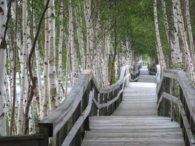
A walkway wending through the waterfowl sanctuary in the Tantramar Marsh near Struts Gallery, Sackville, New Brunswick, Acadia, Arcadia, Nova Francia. Photo: J. R. Carpenter, 2009
So far all my research suggests that Struts is located at the end of this walkway and the best way to get there is to walk this way.
On the Internet, Struts is located at: http://www.strutsgallery.ca/
I don’t speak enough english to understain (…) but i’d like to. A curious French